# Entidades da Simulação

A seguir estão as coordenadas GeoJSON das entidades presentes no cenário de simulação

Visualizador: [http://172.18.35.75:3000/](http://172.18.35.75:3000/)

##### SBR497

<details id="bkmrk-sbr-497-json-%7B-%22type"><summary>GeoJSON</summary>

```json
{
  "type": "FeatureCollection",
  "features": [
    {
      "type": "Feature",
      "id": 0,
      "geometry": {
        "type": "Polygon",
        "coordinates": [
          [
            [
              -48.1622,
              -22.2156
            ],
            [
              -48.1403,
              -22.2004
            ],
            [
              -48.1183,
              -22.1853
            ],
            [
              -48.0963,
              -22.1702
            ],
            [
              -48.0744,
              -22.155
            ],
            [
              -48.0524,
              -22.1399
            ],
            [
              -48.0305,
              -22.1248
            ],
            [
              -48.0086,
              -22.1096
            ],
            [
              -47.9866,
              -22.0945
            ],
            [
              -47.9647,
              -22.0793
            ],
            [
              -47.9428,
              -22.0642
            ],
            [
              -47.9411,
              -22.0504
            ],
            [
              -47.9394,
              -22.0366
            ],
            [
              -47.9378,
              -22.0228
            ],
            [
              -47.9241,
              -22.0294
            ],
            [
              -47.9104,
              -22.0361
            ],
            [
              -47.8967,
              -22.0428
            ],
            [
              -47.9036,
              -22.0588
            ],
            [
              -47.9106,
              -22.0748
            ],
            [
              -47.9176,
              -22.0908
            ],
            [
              -47.9246,
              -22.1068
            ],
            [
              -47.9316,
              -22.1228
            ],
            [
              -47.9385,
              -22.1388
            ],
            [
              -47.9455,
              -22.1548
            ],
            [
              -47.9525,
              -22.1708
            ],
            [
              -47.9549,
              -22.1881
            ],
            [
              -47.9574,
              -22.2054
            ],
            [
              -47.9598,
              -22.2228
            ],
            [
              -47.9623,
              -22.2401
            ],
            [
              -47.9647,
              -22.2574
            ],
            [
              -47.9672,
              -22.2747
            ],
            [
              -47.9696,
              -22.292
            ],
            [
              -47.9721,
              -22.3093
            ],
            [
              -47.9745,
              -22.3266
            ],
            [
              -47.9769,
              -22.3439
            ],
            [
              -47.9955,
              -22.3311
            ],
            [
              -48.014,
              -22.3182
            ],
            [
              -48.0326,
              -22.3054
            ],
            [
              -48.0511,
              -22.2926
            ],
            [
              -48.0696,
              -22.2797
            ],
            [
              -48.0882,
              -22.2669
            ],
            [
              -48.1067,
              -22.2541
            ],
            [
              -48.1252,
              -22.2412
            ],
            [
              -48.1437,
              -22.2284
            ],
            [
              -48.1622,
              -22.2156
            ]
          ]
        ]
      },
      "geometry_name": "geom",
      "properties": {
        "id": "SBR497",
        "feattype": "eac_r"
      }
    }
  ]
}
```

</details><details id="bkmrk-vizualiza%C3%A7%C3%A3o-%C2%A0"><summary>Vizualização</summary>

 [![image.png](https://servicos2.decea.mil.br/br-utm/wiki/uploads/images/gallery/2024-06/scaled-1680-/image.png)
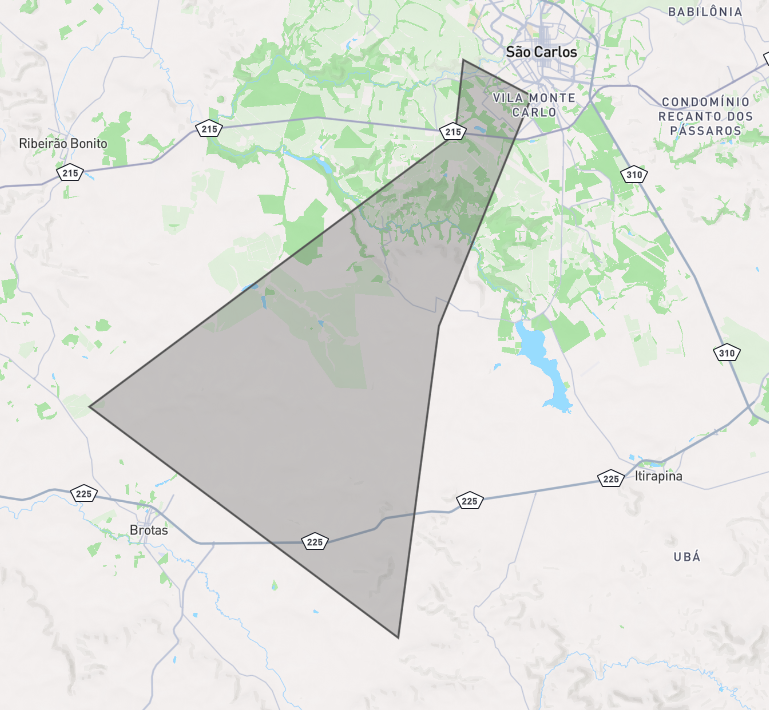
](https://servicos2.decea.mil.br/br-utm/wiki/uploads/images/gallery/2024-06/image.png)

</details>##### OIR USS ICEA

<details id="bkmrk-geojson-%7B%C2%A0-%22type%22%3A-%22"><summary>GeoJSON</summary>

{  
 "type": "FeatureCollection",  
 "features": \[  
 {  
 "type": "Feature",  
 "properties": {},  
 "geometry": {  
 "coordinates": \[  
 \[  
 \[  
 -48.04294926032304,  
 -22.29007270340638  
 \],  
 \[  
 -47.97913316615177,  
 -22.33798336379246  
 \],  
 \[  
 -47.97534728820932,  
 -22.27599508625559  
 \],  
 \[  
 -48.04294926032304,  
 -22.29007270340638  
 \]  
 \]  
 \],  
 "type": "Polygon"  
 }  
 }  
 \]  
}

</details><details id="bkmrk-visualiza%C3%A7%C3%A3o"><summary>Visualização</summary>

[![image.png](https://servicos2.decea.mil.br/br-utm/wiki/uploads/images/gallery/2024-06/scaled-1680-/lROimage.png)
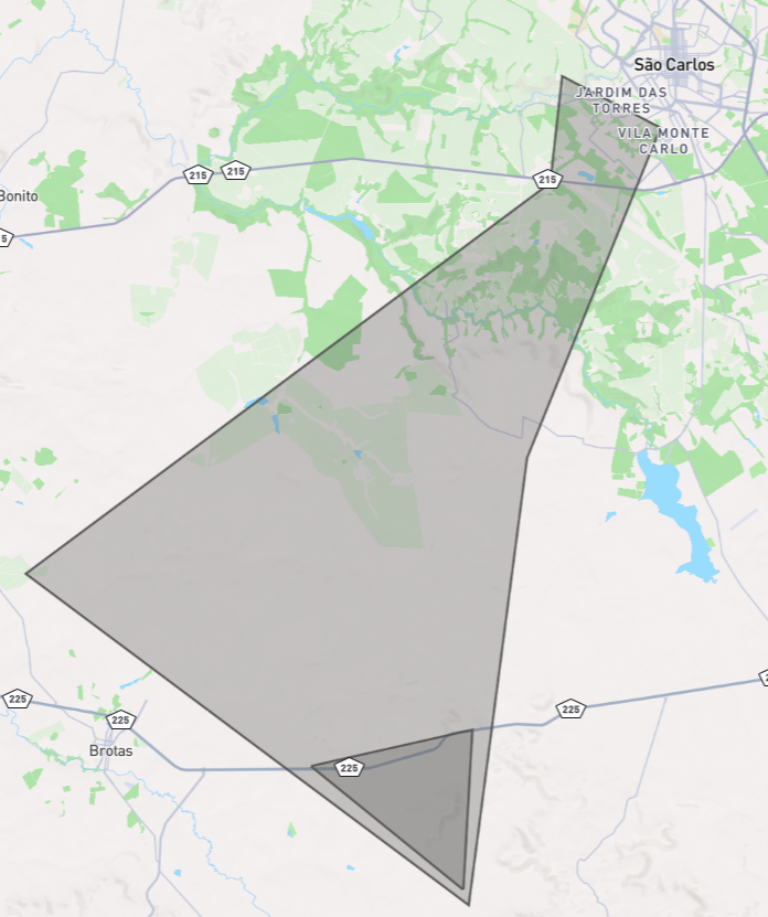
](https://servicos2.decea.mil.br/br-utm/wiki/uploads/images/gallery/2024-06/lROimage.png)

</details>##### Restrição

<details id="bkmrk-geojson-%7B%C2%A0-%22type%22%3A-%22-1"><summary>GeoJSON</summary>

{  
 "type": "FeatureCollection",  
 "features": \[  
 {  
 "type": "Feature",  
 "properties": {},  
 "geometry": {  
 "coordinates": \[  
 \[  
 \[  
 -48.15454075371537,  
 -22.21502857838594  
 \],  
 \[  
 -48.07855594639369,  
 -22.26593911208886  
 \],  
 \[  
 -48.07126578841704,  
 -22.15692404482543  
 \],  
 \[  
 -48.15454075371537,  
 -22.21502857838594  
 \]  
 \]  
 \],  
 "type": "Polygon"  
 }  
 }  
 \]  
}

</details><details id="bkmrk-visualiza%C3%A7%C3%A3o-1"><summary>Visualização</summary>

[![image.png](https://servicos2.decea.mil.br/br-utm/wiki/uploads/images/gallery/2024-06/scaled-1680-/WOpimage.png)
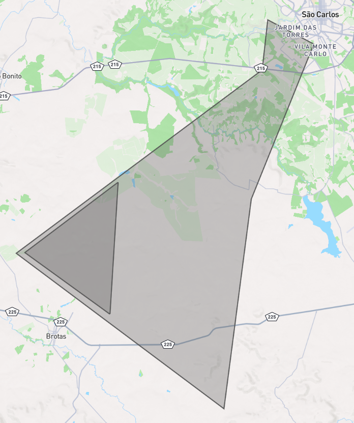
](https://servicos2.decea.mil.br/br-utm/wiki/uploads/images/gallery/2024-06/WOpimage.png)

</details>